 |
| The iPhone version of the map with red route line |
18.07.2012 - In my preparations for Lapland I purchased a very detailed map of the region. As we expected to hike down into Finland on the first day it seemed unnecessary to purchase another one to cover just a few kilometers of rolling hills. If the car hadn't developed engine trouble, then we would easily have reached our starting point and made the necessary progress on the first day. Serious mistake number 1. As it happened, we were well out of our mapped area on the first night and only barely within it on the second.
By some stroke of luck we had found a National Park map information board at the end of the road on Day 1, and had the wit to photograph it with a camera and iPhone just in case. Relying on electronic devices in the wilderness is complete madness, and we were not exactly very far from a road even at the end of the first day, but with the change in weather and our new idea to enter Finland along the eastern slopes of Halti - this little map proved to be essential information when we needed it the most.
 |
| Stuart crouches low to take a few shots of the ice |
Packing up camp very soon becomes a routine affair. With everything compartmentalized in neat Ortlieb waterproof bags I've come to realize the real advantages of being well organized. The weather can change rapidly in the hills and you can go from warm and sunny to cold, wet and windy in a minute and you really don't want to have to think where you packed your waterproofs. With everything in sealed bags then the chances of things getting wet - even if your pack falls in water, is reduced to a minimum.
 |
| Slow melting ice on the river |
You won't find me talking much about my boots, except to say that they work. They more than work. The Haglöf Grym's are no fairy tale (had to put that in) and with the high ankle my feet never ever got wet no matter where I went with them. At the end of the day they were still bone dry, so were my socks - and not the slightest whiff of foot odor. It has to be said (after 20 years of hiking boots) that these are not only the most comfortable boots I have ever worn, but possibly the most comfortable shoes that have ever wrapped themselves around my feet. Remarkable they are. Plus - Stuart - who had arrived in Finland with well prepared but completely inadequate hiking boots and had bought his Haglöf Gryms down at the local outdoor store - wore them for the first time on the hike - something you would never dream of with regular hiking boots.
 |
| Sakari cooking breakfast - or is it lunch? |
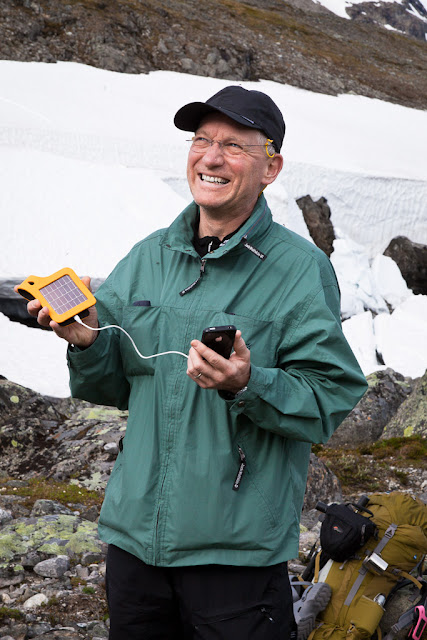
You will find me talking a lot about the Solarstrap solar powered iPhone chargers which we brought with us in the hope of maintaining power over a week. I am a keen iPhone photo app freak and love to make short video clips - but all these are power hungry and the iPhone is not the most energy efficient device despite being the best in every other way.
 |
| Stuart catches the last rays of the sun with the Solarstrap before we head off on day 2 |
To be fair on Suntrica and their Solarstrap iPhone charger - the deterioration in the weather didn't give them much of a chance to prove themselves but I had the luck of having several versions with me fully charged through a USB cable before landing in Kittilä. In fact I had hoped to try out some pre-release products at the same time from Suntrica but with virtually no direct sun after day 1 this was just not going to happen.
 |
| Sakari complete with mosquitoes |
What did happen was a combination of setting up the iPhone to use the least amount of power, i.e., location services off, lower screen brightness, vibrator off, airplane mode and other little tweaks which left me the use of my video and camera apps to use as I like. I had 4 solar straps with me and one spare battery and that was enough for a daily round of videos and other camera stuff. These amazing little devices are very light and having that extra power when you could be in a critical situation (with network coverage) could come in very handy. As we almost never found network coverage we did expose ourselves to some level of risk but we did find spots where there was coverage and kept a log of where they were. On several occasions I woke up with the battery perilously low and with the Solarstrap hooked up to my phone as I walked brought the device up to 97% charge every time. The phone battery never got past 97% charge which I thought might be a software bug, but recharging your phone in the middle of nowhere is a thrill to be savored in any case and well worth the investment if a guaranteed source of power is what you need.
 |
| Sakari walks along the eastern ridge in the foothills of Norwegian Halti |
 |
| Stuart with his Haglöfs, poles and pack. |
 |
| The view looking north as we left the camp on Day 2 |
 |
| Looking south along the river bed towards the Finnish border |
 |
| Sakari - hands free walking - camera always on. |
 |
| View north along the river bed |
Its not easy to walk and take photos, especially when you have all that weight on your back and walking poles in each hand. That is one reason Sakari doesn't use them and prefers to pick his way through the rocky terrain with balletic precision rather than relying on the 4 legged version of hill walking preferred by his companions. Stuart and I would often stop and marvel at his figure - some kind of Giant Ninja Turtle with a green waterproof shell dwarfing his body with two legs deftly picking out the tiny rigid peaks of this miniature mountain range.
 |
| Stuart in front, Sakari close behind having forded the river and heading higher up the slopes |
 |
| Colorful lichens in the desert landscape on the slopes of Halti |
 |
| Stuart reaches the top of the ridge with Sakari not far behind. |
In fact I had three 'cameras' with me. The Canon 5D mkII is my workhorse and came with an 50mm F/1.2 and my EF 28-135 F/3.5-5.6. I rarely change lenses on the move for obvious reasons and so on the first couple of days nearly all the shots are done with the 28-135. I also had the use of the Canon Powershot G1X which came out for the last day. I didn't have spare batteries for the Powershot, but carried 4 spares for the 5D shooting only when the opportunity presented itself while walking and in the evenings and early mornings. Still, I'm happy with some of the shots which show something of a landscape which is at once primeval and raw.
 |
| Clouds turning heavy in the early afternoon |
The disappearance of the mosquitoes which were rather troublesome on the first day was both a good sign and a bad. The ability to do without the fuzzy unfocused view through the head net was a great relief. We were climbing of course, and mosquitoes need oxygen and warmth and the increase in altitude brought with it cooler air and enough wind to blow them away. I can't tell you exactly what the temperature was up there on the hills, but I can say that when Sakari looked over my kit before we left for Lapland he did ask me to take something warmer and I'm very glad he did.
Our thoughts about skirting around the Norwegian Halti to get to the Finnish side evaporated as a band of fog swept over the top of the highest peaks. As the cloud cover thickened, we decided to get to a lower altitude, close to a lake for the night and headed down off the peak in a steep descent on very rocky terrain with massive boulders that slowed us down to only a few meters per minute.
 |
| The steep climb down to camp |
Finally with sight of the first of two small lakes in the valley below we were within range of the map I was carrying and with all the tools at our disposal to plan our route for Day 3. For now the legs were once again wobbly from the day's weight and the stomach aching for something hot.
 |
| Snow lined lake in the hills around Halti |
 |
| Sakari's tent - end of Day 2 |
We set up our camp by the lake, cooked and slept - a deep heavy sleep that comes as easily and thickly as the fog that crept down from the mountain while the wild reindeer herds ran across the snow in the distance.


No comments:
Post a Comment
Write your comment here.
Note: only a member of this blog may post a comment.